The Hook Norton Brewery Co Ltd
Brewery Lane, Hook Norton,
OXON, OX15 5NY
Brewery Lane, Hook Norton,
OXON, OX15 5NY
To help you get out and about and enjoy our wonderful countryside here’s a list of cycle rides – most starting, passing and ending at a Hooky pub!
A massive thank you to Banbury Star Cycling Club for putting these together for us.
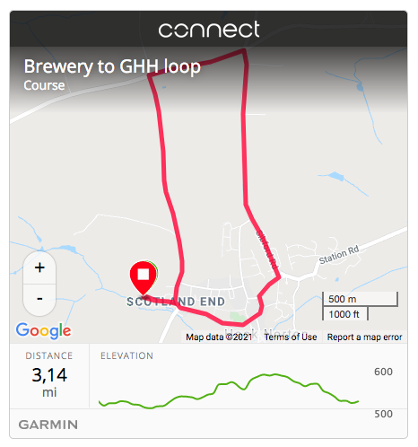
Ride 1: Three pubs and a brewery!
Starting at the brewery, head down Brewery Lane and you’ll come across your first Hooky pub – The Pear Tree. Too early for a stop? Turn left and head up to The Gate Hangs High. Stop for a drink or a bite to eat before heading back down into Hook Norton Village where you’ll pass the third and final pub – The Sun Inn. Then it’s downhill all the way to the brewery.
Type: Loop
Distance: 3.1m
Elevation: 105′
Pubs: The Pear Tree, Hook Norton, The Gate Hangs High, Hook Norton, The Sun Inn, Hook Norton.
Garmin: https://connect.garmin.com/modern/course/34605379
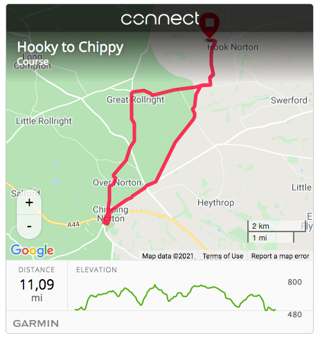
Ride 2: Hooky to Chippy. There and back again, see how far it is.
Starting at the brewery, head down the lane, turning right past the Pear Tree and heading up the hill out of Hook Norton. This is quite a hilly route and please pay attention to inceased traffic volume on main roads when entering and leaving Chipping Norton. Some of the route is single lane road so caution must be given to other road users. The route takes you to the market town of Chipping Norton – The Gateway to the Cotswolds and home to not one but two Hooky pubs. The Fox and Red Lion sit handily overlooking the market square.
Type: Out and Back
Distance: 11m
Elevation: 886′
Pubs: The Fox, Chipping Norton, The Red Lion, Chipping Norton, The Pear Tree, Hook Norton.
Garmin: https://connect.garmin.com/modern/course/34814433
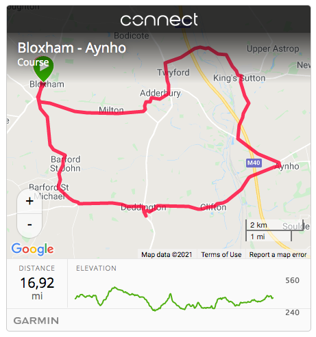
Ride 3: Five pubs and a few hills.
Bloxham is the start and end point for this enjoyable loop taking in five pubs and a few hills on the way.
Type: Loop
Distance: 16.9m
Elevation: 782′
Pubs: The Elephant and Castle, Bloxham, Crown and Tuns, Deddington, Great Western Arms, Aynho, Butchers Arms, Kings Sutton, The Bell Inn, Adderbury
Garmin: https://connect.garmin.com/modern/course/34602705
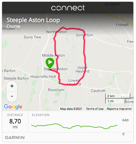
Ride 4: Cherwell Valley up down and around.
Setting off from the charming village of Steeple Aston, head down through the Heyfords before crossing the River Cherwell and Oxford Canal at Somerton then climb up into North Aston, a gentle coast down through Middle Aston ending back at the pub in Steeple Aston.
Type: Loop
Distance: 8.7m
Elevation: 612′
Pubs: The Red Lion, Steeple Aston.
Garmin: https://connect.garmin.com/modern/course/34814983
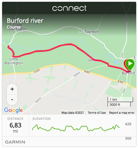
Ride 5: Burford. There and back again, see how far it is.
Starting at The Angel, located just off the busy high street this route takes you out into the stunning countryside surrounding the small medieval town of Burford on the River Windrush.
Type: Out and Back
Distance: 6.8m
Elevation: 310′
Pubs: The Angel, Burford.
Garmin: https://connect.garmin.com/modern/course/34607280
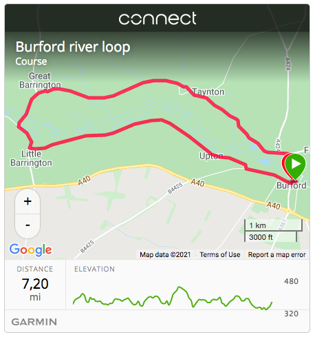
Ride 6: River Windrush loop.
Starting at The Angel, located just off the busy high street this route takes on a lovely loop around the River Windrush through the charming Little and Great Barrington villages.
Type: Loop
Distance: 7.2m
Elevation: 363′
Pubs: The Angel, Burford.
Garmin: https://connect.garmin.com/modern/course/34809975
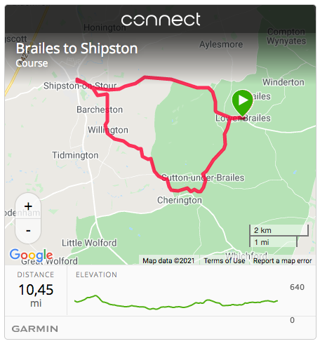
Ride 7: Brailes to Shipston On Stour loop.
“Brailes” is made up of Lower and Upper Brailes, located on the Warwickshire / Oxfordshire border, 3 miles east of Shipston on Stour. The towns name derives from being known in ancient times as ‘Sheep-wash-Town’. Shipston was for a long time an important sheep market town. Today it is a charming historic and thriving town with interesting and unusual features.
Type: Loop
Distance: 7.2m
Elevation: 363′
Pubs: The George, Brailes, The Coach and Horses, Shipston On Stour, The Cherington Arms, Cherington.
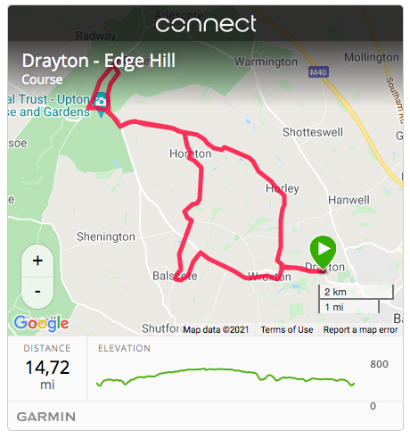
Ride 8: Drayton – Edge Hill.
Edge Hill gave its name to the first battle of the English Civil War, in which it was a prominent feature. The Castle Inn is an eccentric building of local Hornton Stone built in the 1740s to the designs of Sanderson Miller (1716–80). Balscote is a pretty little village, built mainly of the local dark honey-coloured ironstone. The parish church, the Church of St. Mary Magdalene features a Norman font and an Early English style window. Most of the present church building is 14th century, in the Decorated Gothic style.
Type: Loop
Distance: 14.7m
Elevation: 778′
Pubs: The Roebuck, Drayton, The Castle, Edge Hill, Butchers Arms, Balscote.
Garmin: https://connect.garmin.com/modern/course/34603335
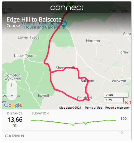
Ride 9: Edge Hill to Balscote.
How many routes start and end at a castle that’s also an award winning pub, restaurant and hotel? The local in Balscote’s not to bad either with a fantastic beer garden to while away a few hours.
Type: Loop
Distance: 13.6m
Elevation: 499′
Pubs: The Castle Inn, Edge Hill, Butchers Arms, Balscote.
Garmin: https://connect.garmin.com/modern/course/34813420
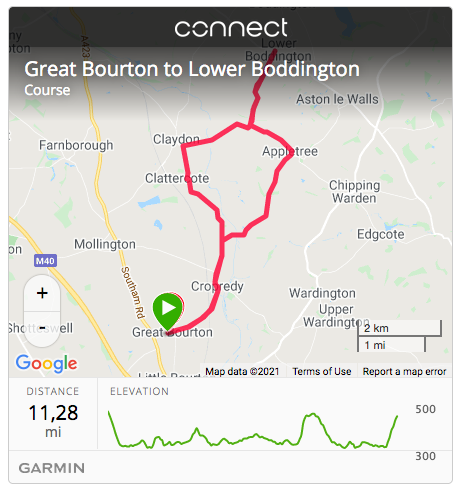
Ride 10: Great Bourton to Lower Boddington.
It may be hard to leave The Bell with it’s old world charm and fantastic views of the church clock tower but a lovely ride awaits with another pub at the end. The Carpenters Arms awaits you in Lower Boddington, offering great home cooked food and of course refreshing Hook Norton ales!
Type: Out and Back
Distance: 11.3m
Elevation: 550′
Pubs: The Bell, Great Bourton, The Carpenters Arms, Lower Boddington.
Garmin: https://connect.garmin.com/modern/course/34606414
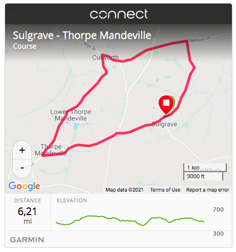
Ride 11: Sulgrave to Thorpe Mandeville.
Whichever pub you choose to start at you’ll be guaranteed fantastic food, charming and unique interiors and large beer gardens.
Type: Loop
Distance: 6.2m
Elevation: 382′
Pubs: The Star Inn, Sulgrave, The Three Conies, Thorpe Mandeville.
Garmin: https://connect.garmin.com/modern/course/34815435
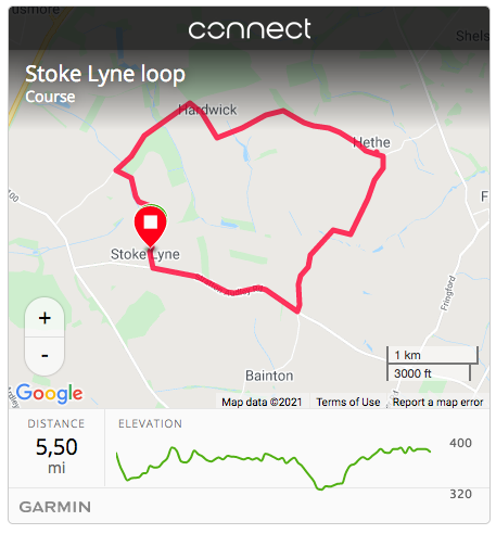
Ride 12: Stoke Lyne Loop.
Run by Mick The Hat and his wife Jean, the pub is an irreplaceable rural gem. The pub is listed in CAMRA’s National Inventory of pub interiors of outstanding historic interest as being one of fewer than 250 pubs left in Britain to have an interior of outstanding heritage and interest. One that deserves to be ticked off any pub bucket list. Opening times change like the wind so always best to check to avoid dissapointment!
Type: Loop
Distance: 5.5m
Elevation: 132′
Pubs: The Peyton Arms, Stoke Lyne.
Garmin: https://connect.garmin.com/modern/course/34815929
© 2026 Hook Norton Brewery | Credits | Site map | T&Cs | Privacy Policy | Cookie Policy.
